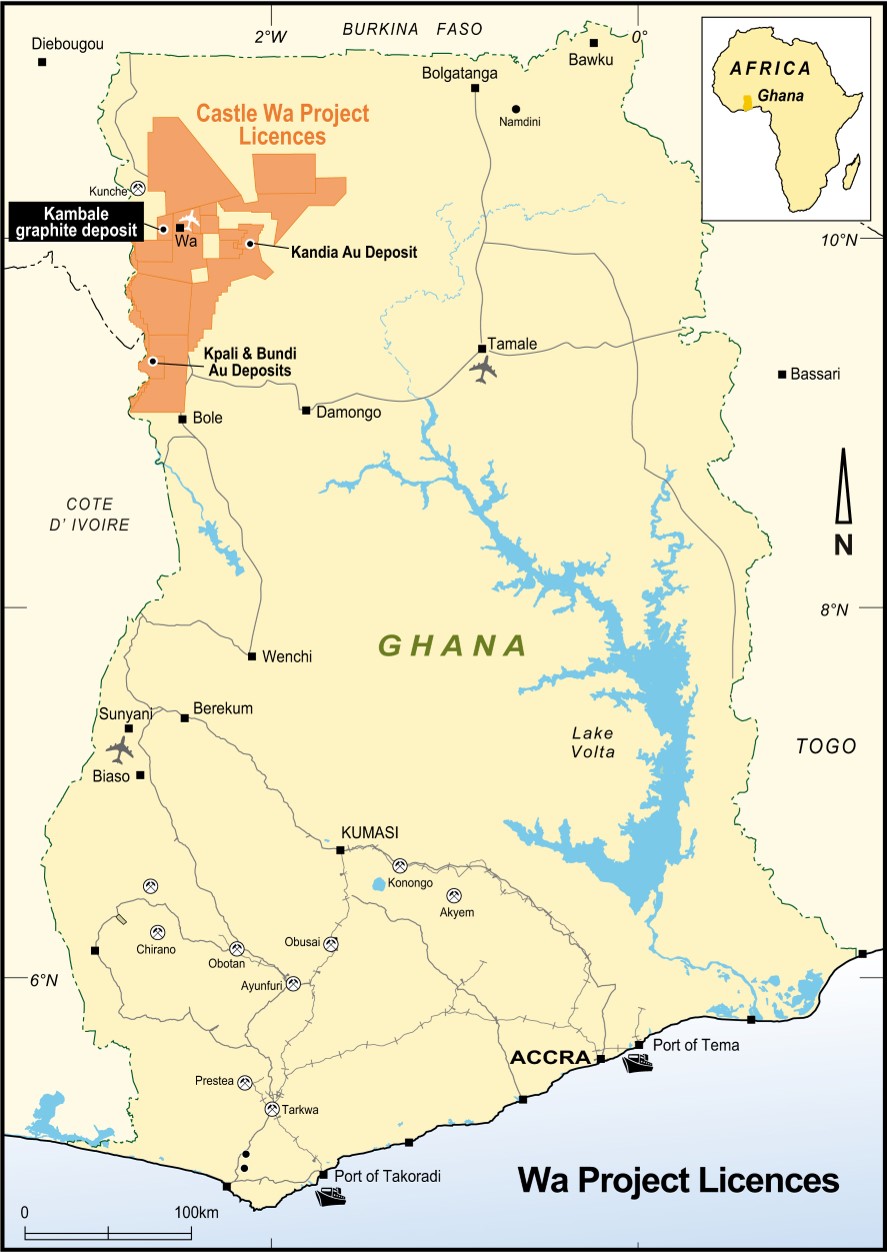
Introduction
The Wa Project is situated in NW Ghana near the border with Burkina Faso and consists of the Wa, Jang and Wonachiyiri Reconnaissance Licences and the Julie West and Kandia Prospecting Licence applications.
The Wa Project was acquired in November 2007 and in 2009 the Jang and Wonachiyiri RLs were applied for covering a total area of more than 12,000 km².
The 0.3Moz Julie gold deposit is located within an excised portion of the Wa Project and the 0.7Moz Kunche and Bepkong gold deposits are located 50km north.
In 2009 Castle discovered and defined a near surface JORC Code compliant Resource Estimate of 56,000 ounces for the Julie West deposit comprising 415,000 tonnes @ 4.2g/t gold from the natural surface to 80m.
Exploration Results
Exploration during 2009/10 has focused on four regional scale highly prospective gold corridors known as:
- Julie-Jang Trend - 50km long trend
- Kandia - new 30km corridor of anomalous gold in soils
- Wa South (Batie West trend) - 60km long corridor
- Wa-Lawra Greenstone Belt - 80km of untested greenstone
Julie-Jang Trend
The Julie-Jang Trend covers a 50km long prospective gold corridor extending from the Julie West gold deposit to the NNW striking Jang Fault. Regional scale geochemical sampling has confirmed anomalous gold values in soils and a program of detailed sampling and airborne geophysical surveys are planned in preparation for a large program of drilling to test the targets generated.
The Julie West gold deposit was discovered by Castle in June 2008 from an initial 44 rock samples that averaged 13.2g/t gold. Subsequent drilling programs delineated a continuous 500m long NW striking laminated pyritic quartz vein.
Runge Limited (Perth) undertook an independent resource estimate in April 2009 and estimated a total Indicated and Inferred Mineral Resource of 56,000 ounces calculated from surface to 80m depth comprising 415,000 tonnes @ 4.2g/t gold.
Following the resource estimate 185 RC drill samples were submitted for 1kg Bulk Leaching Extractable Gold (BLEG) analysis over 36 hours with following outcomes:
- High grade assays up to 213g/t and 199g/t gold were returned compared to previous fire assay analysis that reported 30.9g/t and 71.9g/t gold respectively
- Average cyanide recoverable gold over 36 hrs was 91% with additional leach time likely to achieve enhanced recoveries
- Excluding high grade results, 36hr BLEG analysis reported 6% higher overall grade (33% higher including high grade results) than the original fire assay
- Average tail grade of 0.33g/t gold (excluding the two high grade assays that require further leach time) was returned from the BLEG samples
Julie West Significant RC Results
| 5m | @ 28.50 g/t | gold | (JWRC001) |
| 2m | @ 41.70 g/t | gold | (JWRC002) |
| 3m | @ 13.02 g/t | gold | (JWRC003) |
| 2m | @ 14.40 g/t | gold | (JWRC007) |
| 3m | @ 10.30 g/t | gold | (JWRC008) |
| 2m | @ 13.70 g/t | gold | (JWRC010) |
| 2m | @ 14.87 g/t | gold | (JWRC014) |
| 7m | @ 23.63 g/t | gold | (JWRC026) |
| 3m | @ 10.90 g/t | gold | (JWRC027) |
| 2m | @ 15.59 g/t | gold | (JWRC028) |
| 3m | @ 14.36 g/t | gold | (JWRC029) |
| 2m | @ 17.15 g/t | gold | (JWRC031) |
| 3m | @ 14.19 g/t | gold | (JWRC032) |
| 2m | @ 19.21 g/t | gold | (JWRC050) |
| 2m | @ 12.07 g/t | gold | (JWRC053) |
| 2m | @ 17.55 g/t | gold | (JWRC054) |
| 2m | @ 11.07 g/t | gold | (JWRC056) |
| 3m | @ 9.94 g/t | gold | (JWRC057) |
Four deep holes were drilled to test the down dip extent of the high grade Julie West gold mineralisation. The RC holes tested the vein extensions approximately 250m down dip of the natural surface. All holes hit narrow quartz veins and/or alteration zones where predicted confirming that the vein structure is consistent and predictable down dip. Mineralisation was reported in all holes including , 1m @ 0.71 g/t gold from 152m (JWRC116) and 4m @ 0.82 g/t gold from 145m (JWRC117) confirming that the controlling structure is persistently mineralised and capable of hosting further high grade mineralisation.
Rockchip sampling along an outcropping quartz vein 1.4km south of the main Julie West vein reported surface grades up to 30 g/t gold. RC drilling of these targets and nearby soil geochemical anomalies identified the vein hosted Alpha, Bravo and Charlie gold prospects with significant results including:
| 1m | @ 7.47 g/t | gold | from 12m | (JWRC067) |
| 5m | @ 5.12 g/t | gold | from 5m | (JWRC068) |
| 3m | @ 2.33 g/t | gold | from 1m | (JWRC065) |
| 4m | @ 1.48 g/t | gold | from 4m | (JWRC069) |
During 2010 further RC drilling tested the Alpha and Bravo quartz vein mineralisation with additional shallow gold mineralisation intersected from the Alpha vein and deeper extensions to the Bravo mineralisation were also reported. Results include:
| JWRC109 - Alpha vein | 5m | @ 6.86 g/t | gold | from 19m |
| JWRC110 - Alpha vein | 3m | @ 7.26 g/t | gold | from 49m |
| JWRC106 - Bravo vein | 2m | @ 2.09 g/t | gold | from 82m |
| JWRC107 - Bravo vein | 4m | @ 2.49 g/t | gold | from 87m |
The gold mineralisation at these zones is hosted by laterally continuous quartz veins. The veins remain open and collectively form a southern corridor of mineralisation that is expected to host additional veins systems under the thin soil cover.
In March 2010 RC drilling intersected primary gold mineralisation north of the Julie West deposit that reported 9m @ 22.1g/t gold from a zone of pyritic vein quartz. This high tenor drill result was followed up with a program of 2,828 metres of drilling testing for extensions to this mineralisation.
Drilling on 40m, 80m and 120m spaced sections intersected flat to shallow dipping zones of quartz vein mineralisation that appear to be oriented in an approximately east-west direction. This flat lying mineralisation has no surface expression and presents an intriguing exploration target. Further drilling is proposed along strike and to test other strong soil anomalies in this area. Significant drill intercepts include:
| JWRC 135 | 5m | @ 8.30 g/t | Au | from 25m |
| JWRC 138 | 4m | @ 1.22 g/t | Au | from 30m |
| JWRC 141 | 4m | @ 1.09 g/t | Au | from 0m |
| JWRC 144 | 4m | @ 1.21 g/t | Au | from 35m |
| JWRC 145 | 2m | @ 1.79 g/t | Au | from 60m |
A new 1.2km long gold anomaly parallel to the high grade Julie West gold vein was defined by detailed soil sampling in June 2010. This anomaly is well defined at +100ppb gold and includes peak values of 490ppb and 2,255 ppb gold.
There is no recorded outcrop in the area and the anomaly may overlie high grade, vein hosted gold mineralisation. Access to this area is good and a 2,500m RC program is proposed to test this target.
Kandia
The Kandia prospect was discovered in April 2010 during a program of reconnaissance field mapping. During this program a large area of previously unknown artisanal gold workings was discovered that comprise three main groups developed over approximately 600m of strike. The largest single group of workings is developed over a 400m strike length with mineralisation exposed in workings over 40m width. Collectively the three groups of workings identify gold mineralisation in a corridor 400m wide that presents as a highly ranked target.
Gold mineralisation at Kandia is seen to occur within altered Birimian age metasediments and schists, that on a regional scale sit on a major granite/sediment contact that can be traced within Castle's licences for at least 25km.
A sampling and mapping program is underway at Kandia, and along the regional trend of the mineralisation. This work represents the first known systematic gold exploration conducted in this area.
A second group of gold workings was found at Bisakan 10km to the south west where east-west trending quartz vein hosted gold mineralisation is developed in sheared granitic rocks over a few hundred metres of strike. The mineralisation at Bisakan is a different style to that seen at Kandia and demonstrates that a number of gold mineralising events have occurred in this area.
Results received to date have defined a +15km long open ended gold anomaly.
Of particular interest is an area south of the Kandia workings that produced a stronger gold in soils response than the Kandia workings themselves. This area exhibits a continuous coherent gold anomaly approximately 300m wide over a 6km strike length with a distinct orientation change at the northern end possibly reflecting an underlying structural change.
The first RC drilling program to test the Kandia artisanal gold workings was undertaken in May 2010 and outlined a number of strike extensive zones of sediment hosted gold mineralisation.
Significant results from 5 metre composite sampling of the drilling program include:
| KARC016 | 5m | @ 1.43 g/t | Au | from 25m |
| 5m | @ 0.89 g/t | Au | from 45m | |
| KARC017 | 5m | @ 0.70 g/t | Au | from 30m |
| KARC018 | 10m | @ 1.19 g/t | Au | from 0m |
| KARC019 | 10m | @ 1.44 g/t | Au | from 35m |
| KARC021 | 6m | @ 1.15 g/t | Au | from 60m |
| KARC027 | 16m | @ 1.09 g/t | Au | from 50m |
19 of the 28 holes drilled reported gold mineralisation defining at least two parallel zones of sediment hosted gold mineralisation over a 500m strike length that remains open along strike. Further drilling is planned for this area.
By the end of 2011 Castle had completed extensive soil sampling, airborne geophysical surveys and completed 264 RC drill holes for 19,541m along the Kandia Trend.
A maiden Resource estimate for Kandia was completed for two mineralised zones named the “4000 Zone”and “8000 Zone” in December 2011.
| Material Type | Indicated | Inferred | Total | ||||||
|---|---|---|---|---|---|---|---|---|---|
| Tonnes (t) | Au (g/t) | Au (ounces) | Tonnes (t) | Au (g/t) | Au (ounces) | Tonnes (t) | Au (g/t) | Au (ounces) | |
| Oxide | 131,300 | 1.0 | 4,100 | 51,000 | 1.3 | 2,100 | 183,000 | 1.1 | 62,000 |
| Fresh | 1,841,500 | 1.0 | 58,700 | 1,327,200 | 1.0 | 42,500 | 3,169,000 | 1.0 | 101,200 |
| Total | 1,973,000 | 1.0 | 62,900 | 1,379,000 | 1.0 | 44,600 | 3,351,000 | 1.0 | 107,500 |
The definition of this shallow gold resource was achieved less than 10 months since RC drilling first commenced in this area and clearly demonstrates that outcropping gold deposits are still capable of being discovered in Ghana.
Kandia is the fourth greenfields gold occurrence to be discovered by Castle since 2008 within the Wa Project - these deposits are spaced over 40km in different stratigraphic sequences confirming that the Wa Project has been subject to a variety of gold mineralising episodes and styles.
The total gold resource for the Wa Project now totals 163,700 ounces and total gold resources for Castle in Ghana total 267,000 ounces. All gold resources have been discovered by Castle after completing geochemical soil programs and following up anomalous areas with RC and/or diamond drilling.
Wa South (Batie West trend)
The Wa South prospect area is located at the south and southwest end of Castle's 12,000km² Wa Project and includes the interpreted extension of the Batie West shear zone. Soil sampling in 2010 defined at least 11 large new gold geochemical anomalies with an aggregate strike length of >60km including:
- 2km wide +100ppb gold anomalous zone south of Batie West structure
- 10km long anomaly flanking margin of internal granite
- multiple anomalies within Wa Lawra greenstone belt rocks
Regional scale first pass soil sampling was conducted on traverses spaced between one and five kilometres apart. The sample lines were oriented east-west targeting both the Wa-Lawra and Bolgatanga greenstone belts and the extension to the Batie West shear zone.
Sampling has been underway since late 2009 and to May 2010 5,403 samples were collected representing approximately 270 line kilometres of gridding and sample collection. Analytical results have now been received for the southern portion of the sampled area and have defined at least 11 regional scale gold anomalies. Collectively these anomalies highlight gold trends over 60km of strike.
Anomalous gold in soils values were reported against very low background levels providing specific corridors for infill sampling, geological mapping and rock chip sampling. In most cases the sampling is too wide spaced to draw conclusive trends with confidence. However, nearly all anomalous areas fall on major structures and/or lithological boundaries which are considered favourable sites for gold mineralisation. Detailed sampling and mapping is required for all targets identified.
Of particular significance is
- a 2km wide zone of anomalous soils reporting above 100ppb gold. This anomaly is situated immediately south of the interpreted extension to the Batie West shear zone on the southern margin of an intrusive granite. The Batie West shear zone is related to gold mineralisation at Ampella's (ASX:AMX) 1.2 million ounce Konkera gold deposit in Burkina Faso 50km to the north west.
- a 10km long anomaly interpreted to overlie the eastern margin of an internal granite at the interpreted intersection with the Batie West structure.
- a continuous 20km long anomaly defined in the central southern portion of the project area and extends south to the historic artisanal Jantigi gold workings 15km east of the town of Bole.
- a 5km and 3km long anomaly on the east side of the project along strike from historic gold mineralisation at Senyon 20km to the SW.
Infill sampling and mapping is underway with additional sampling teams employed to quickly advance these targets in preparation for drilling.
Wa-Lawra Greenstone Belt
This exploration corridor represents the Birimian age greenstone rocks that extend south from the Kunche/Bepkong gold deposits (0.75Moz) located 25km to the north. This greenstone sequence has never been drilled and only limited and incomplete historic soil data has been collected. Systematic soil sampling is proposed to be undertaken in the latter part of 2010 in preparation for drilling of targets generated.
Updated July 2010